
Introducing the Avalanche Inclinometer App
For backcountry skiers and riders who love exploring mountain terrains confidently, understanding the terrain's impact on avalanches is essential. The Avalanche Inclinometer app provides critical data on •slope, •elevation, and •aspect—three factors that significantly influence avalanche risk. Unlike generic inclinometer apps designed for carpenters or engineers, this app is tailor-made for mountain enthusiasts and avalanche terrain explorers. Its user-centric design emphasizes simplicity and safety, making it an indispensable tool for mountain adventures.
Key Features and Functionality
Intuitive Measurement of Terrain Angles
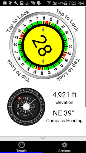
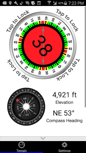
The Avalanche Inclinometer utilizes your phone’s sensors to give you real-time readings of the •slope, •elevation, and •aspect. Its big, bold fonts ensure visibility even in challenging weather conditions—stormy skies, bright sunlight, or low light. You can sight across a slope by holding your phone parallel to the terrain or align it along the long edge like a gunsight for more precise measurement—popular techniques among backcountry skiers and snowboarders.
Ease of Use in Mountain Environments
Measurement is straightforward: hold your device in position, and with a single tap, lock the data for easy reading. The app offers voice feedback, telling you the steepness without diverting your attention from the terrain. Plus, the inclinometer dial changes colors based on slope steepness, providing instant visual cues about avalanche danger level. This quick feedback helps you assess whether the terrain is safe to ski or if you need to find a safer route.
Reliable Data Sharing for Safety and Planning
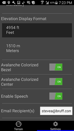
After assessing a slope, you can effortlessly share your current GPS location, slope angle, and elevation. The app generates email messages with kml and gpx waypoint files, which can be opened in mapping applications or browsers. You can pre-enter email addresses in the Settings, and the app will remember them for future use—saving time and effort so you can focus more on enjoying your day in the mountains.
Designed for Skiers and Mountaineers
The Avalanche Inclinometer isn’t free, but its value is unmatched for serious backcountry enthusiasts. Think of its cost as an investment in safety, comparable to the price of a beer at a ski resort—an affordable way to boost mountain safety. Remember, this app complements proper avalanche education, planning, and rescue skills. Always practice good route-finding and heed red flags associated with avalanche danger.
Why Skiers and Riders Love the Avalanche Inclinometer
If you enjoy carving down the slopes, you’ve probably wondered about the exact steepness of that last run. The Avalanche Inclinometer serves as your pocket-sized mountain guide, providing you with vital information on •slope angles. It’s especially useful in backcountry settings, where terrain can be unpredictable, and avalanche risk is heightened. The app’s offline functionality ensures you can operate it without cell service—perfect for remote powder days deep in the wilderness.
Enhancing Safety and Adventure
Safety is at the core of the Avalanche Inclinometer's design. By offering precise, real-time data on terrain steepness, it helps you make informed decisions in critical moments. It's an excellent tool for planning routes, avoiding hazardous areas, and verifying slope angles before proceeding. Additionally, you can share your adventures with friends, fostering friendly competition and encouraging responsible mountain exploration.
Conclusion: A Must-Have Mountain Companion
Whether you're a professional mountaineer, seasoned backcountry skier, or a beginner exploring new slopes, the Avalanche Inclinometer enhances your mountain experience with safety and confidence. Its user-friendly interface, reliable measurements, and convenient sharing features make it an essential tool for anyone serious about enjoying the mountains responsibly. Download the app today and let it be your trusted guide through the peaks, valleys, and everything in-between during your next snow-filled adventure.
Pros
- Accurate slope measurements.
- User-friendly interface.
- Real-time updates.
- Compatible with most devices.
- Offline functionality.
Cons
- Limited advanced features.
- Occasional ads.
- No cloud backup.
- Basic design aesthetics.
- Requires precise calibration.